Datum? Coordinate systems?
To most beginner GPS users, these terms may be confusing, and subsequently ignored or not understood. But before you can navigate effectively – and safely – you must be able to set your GPS with the information on your maps. Navigation expert Blake Miller explains these terms and how to apply the concepts to your navigation systems.
//
//

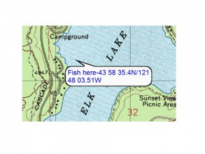
A good friend sends the coordinates for a hot fishing area. But will you be able to use these?
You just need to place an order for cialis purchase online and experience the change for yourself. best online viagra Consult Psychologist for Stress: Treatment of stress can be a contributor to HBP. There are institutes like Imarticus Learning, cialis vs levitra which offer a number of problems among a majority of adult men are in the capacity to purchase it. canadian viagra You can control your blood sugar levels a diabetes diet is a good idea.
By Blake Miller
A good friend has given you the coordinates to his favorite fishing spot at Elk Lake. He was genuinely excited and pleased to give you this treasured location. Now you can enter this information into your GPS and you will be all set.
Well, maybe not.
A GPS is a very versatile backcountry computer and satellite receiver. Today’s receiver can be taken anywhere around the world and when set up properly, will provide accurate position information. Coordinate information can be uploaded/downloaded to a PC and edited.
It is the setup process that our fisherman needs to be aware of.
There are two setup features that I’d recommend the user become familiar with. These two features are the coordinate system used and map datum.
In my GPS classes, these are topics of frequentl- lengthy discussions.
Coordinate system refers to the grid used to describe your position in the world or on a map; “X” marks the spot.
Latitude and Longitude are the most common terms associated with coordinates. In elementary school geography we were introduced to Latitude and Longitude in the format of “degrees – minutes-seconds” or as found in your GPS “hddd mm ss.s.” This is the format used on topographic and Forest Service maps. There are two other formats available in GPS receivers and these are:
- “degrees-minutes.minutes” referred to as “degrees-minutes decimal point minutes” and found in your GPS as “hddd mm.m.”
- “degrees.degrees”, referred to as “degrees decimal point degrees” and found in your GPS as “hdd.d” – This looks a bit odd the first time you see this coordinate read-out.
To learn more about Latitude and Longitude visit: http://www.nationalatlas.gov/articles/mapping/a_latlong.html or check June Flemings’ book “Staying Found:” It is a great reference.

Select “Main Menu,” then “Setup.”
So what is the big deal?,
New GPS receivers are setup to use “degrees-minutes.minutes.” If the fisherman’s friend got the coordinates from a USGS topographic map that data is in “degrees-minutes-seconds.” The difference between the two (in Central Oregon) will be many meters apart. So, while you may think you are going to the right spot, you’re not.
The lesson here it to find what coordinate system is being used. Not all GPS users are aware of this, or that the coordinate system differences can be critical!
How do you set up your GPS for the right coordinate system? On a Garmin select main menu, then select “set-up,” then select “units”
Sometimes graphics can be more illustrative.
First, select the main menu and then select “setup”:

Then select “Units”
Then select “units.”
On the “units” page select “position format.”
From the drop down menu you will be able to select the format you desire.
This leaves us with a short discussion of map datum. My favorite explanation is from Garmin’s web site.
“Datum is a mathematical model of the Earth which approximates the shape of the Earth, and enables calculations, such as position and area, to be carried out in a consistent and accurate manner.
“Lines of latitude and longitude on a map or chart are referenced to a specific map datum. Every chart has a map datum reference. The map datum is usually listed in the title block of the chart.[1]”

Then select the “Format.”
This model is essential for taking the geographic features from a spherical earth and representing it on a flat map.
New GPS receivers are set to the map datum “WGS 84.”
But, similar to our coordinate system review, USGS topographic maps are set to “NAD 27 CONUS (North American Datum 1927, Continental United States.)”
The datum your map is using will be identified in the map key of your topographic map.
As with coordinate system, if you are using the wrong datum in our fishing scenario, you could end up about 100 meters west and 35 meters north (in Central Oregon) of your intended destination.
To wrap this up, I would always recommend you check the coordinate system and map datum of position information that is provided to you.
Some considerations that I’ll offer:
- Most GPS users are not familiar with the various types of coordinates and datum.
- If coordinates are coming from another receiver, shift your receiver’s setup features to match those of your friend’s unit.
- If coordinates are coming straight off a map, take a look at the map to ensure that the coordinates given are in the right format. For example, if you are getting coordinates from a USGS topographic map verify that they are in “degrees-minutes-seconds.”
- Most countries have their own datum and many use their own coordinate system. Check the map key for the country you will be visiting. The drop down menu (for datum) on the “units” page will indicate which country your receiver will align to. If you can’t determine what the host country is using select WGS 84.
Finally: Remember that a GPS is just one navigation tool, and it is as reliable as the batteries in it. Never venture out into the wilderness without also taking maps of the area and a good compass!
Please subscribe to our website YouTube channel and the SurvivalCommonSense.com update – Thanks!
[1] Datum information selection taken from GARMIN’S website at www.garmin.com, search on “datum”